Forecast update: Heavy snow, plentiful moisture looks increasingly likely for Denver, Front Range of Colorado

We continue to track the potential for a wet, heavy snowfall across the region for the latter half of the week. Of course, there remains uncertainty around the details, and like every system, this one has some unique pros and cons going for it. Still, guidance is supportive of plentiful moisture across the region and likely some good accumulating snow for some of us.
On several measures, this setup is right on time. El Niño? ✅ Mid-March? ✅ Slow-moving cutoff low? ✅ Gulf moisture? ✅ That said, some things aren't exactly textbook about this setup which leaves us a little hesitant to offer too high a confidence around the heavier snowfall potential some models are indicating.
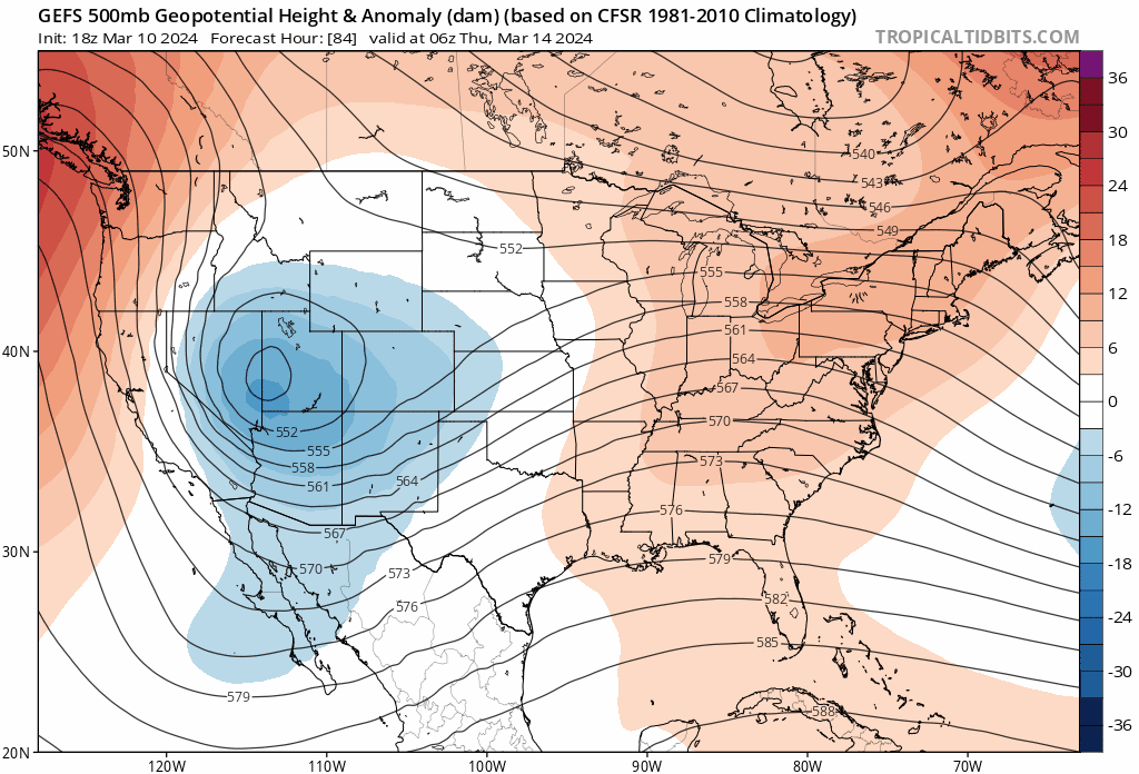
Much of that uncertainty revolves around what we discussed yesterday – a retrograding midlevel cutoff low that never really wants to scoot in the "sweet spot" for a heavy, prolonged upslope snow along the Front Range. Here's the last 4 runs from the GFS ensemble model for early Thursday morning. The center of the low (blues) are over western Utah, southeast Nevada) vs centered a bit more east over the Four Corners.
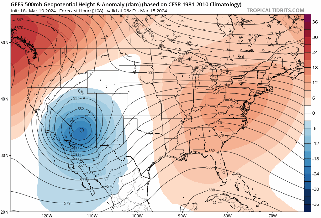
By Friday morning we see it centered over Arizona, not horrible perhaps (at least compared to some prior runs), but very little easterly progression of the low, and a tendency for it to want to sink pretty far south and west of us which isn't confidence inspiring...
The good news if you are hoping for some water (snow!) is that this setup has a few other things going for it.
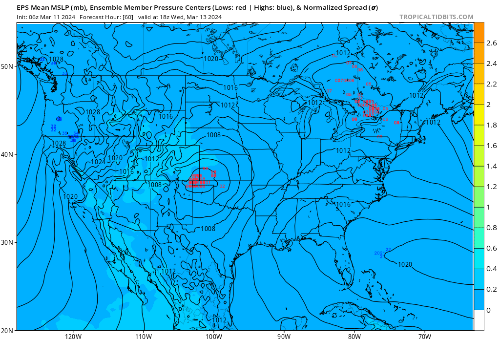
For one, guidance is setting up a good surface low east of the hills, which is in a pretty good spot to fetch that Gulf Moisture we rely on for a "classic" upslope event in March. Below is a look at the latest forecast from the European ensemble model which shows a good cluster of surface lows from its members over southeast Colorado/Oklahoma panhandle:
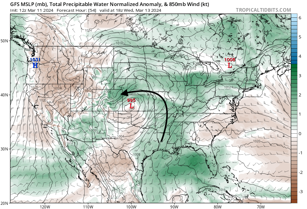
The GFS shows quite nicely that anomalous moisture getting pulled up from the Gulf around that low and up against the Front Range:
Depending on exactly where that low sets up will change who sees the greatest moisture/snow. Models at times show a more northerly/northeasterly upslope which would favor foothills/Palmer south and southwest of Denver, while other times a more easterly flow which would be more beneficial, if you will, to more folks along the Front Range.
You may also note in the image above that this is Wednesday morning. Guidance has been a bit quicker pulling that moisture into eastern Colorado on Wednesday, which may or may not be a good thing. One potential downside is if we see a slug of moisture arrive Wednesday before enough cooling, which would lead to more rain/mixed precipitation at the onset and thus cutting into those overall snowfall totals.
In short, a lot of factors at play.
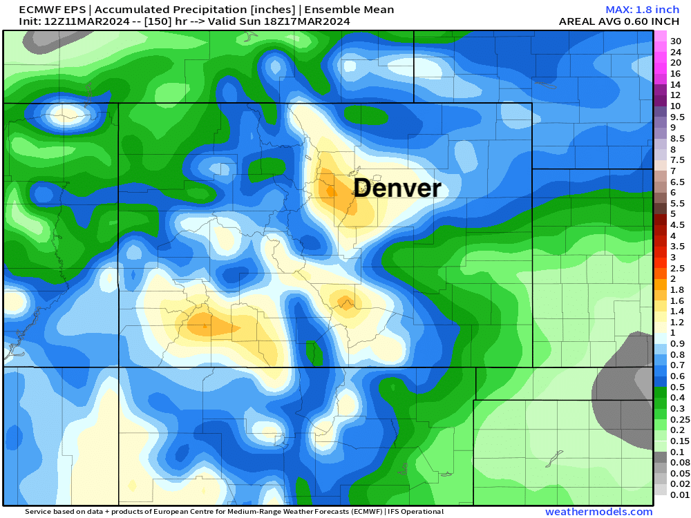
Details aside, ensembles remain quite bullish with regard to potential precipitation with this event. Total precip from the Euro today is in the 1 to 1.8" range across the greater Denver metro area and adjacent foothills. (!!) And really this aligns well (if even a bit low) with other global ensemble models.
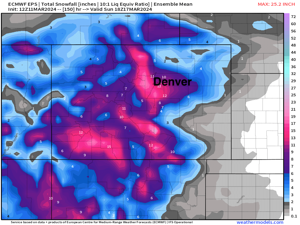
At 10:1 (snow to liquid ratio) that would suggest upwards of 12" of snow for most of us from this event. Given some questions about how fast we change to snow, and what ratios we average through the duration that may end up a bit high, we could perhaps see some more like 8:1 or 9:1 ratios, but still, a healthy snow.
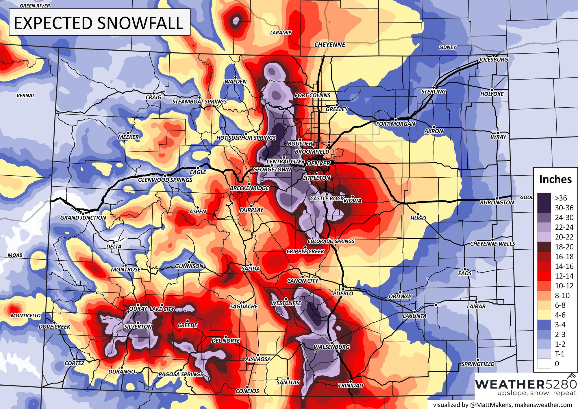
Here is the 10:1 snowfall map from the European ensemble as of this morning – that's upwards of 10" across the entire metro area, favoring the foothills west of Denver and Palmer Divide vs Fort Collins and even COS where downsloping may be more of an issue.
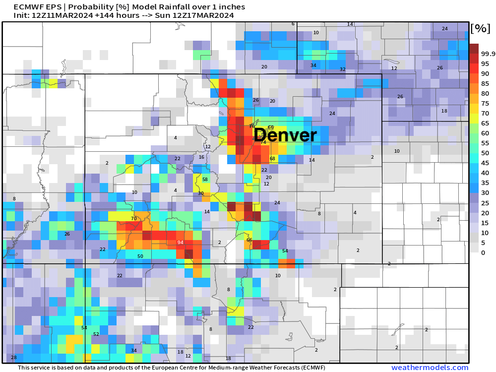
And finally a look at probabilities shows the Euro with a better than 60% chance we see 1" of liquid through the end of the week in Denver, and upwards of 80% for those upslope favored locals to our west. Good stuff.
Snowfall forecast
Here's a look at our initial snowfall forecast for this event. PLEASE make sure you visit www.weather5280.com frequently as this outlook may change given all the moving parts we discussed above. For now, plan for a wet and impactful snow across the region later this week – but details on who sees how much snow will continue to be tweaked over the next day or so.
Timeline and impacts
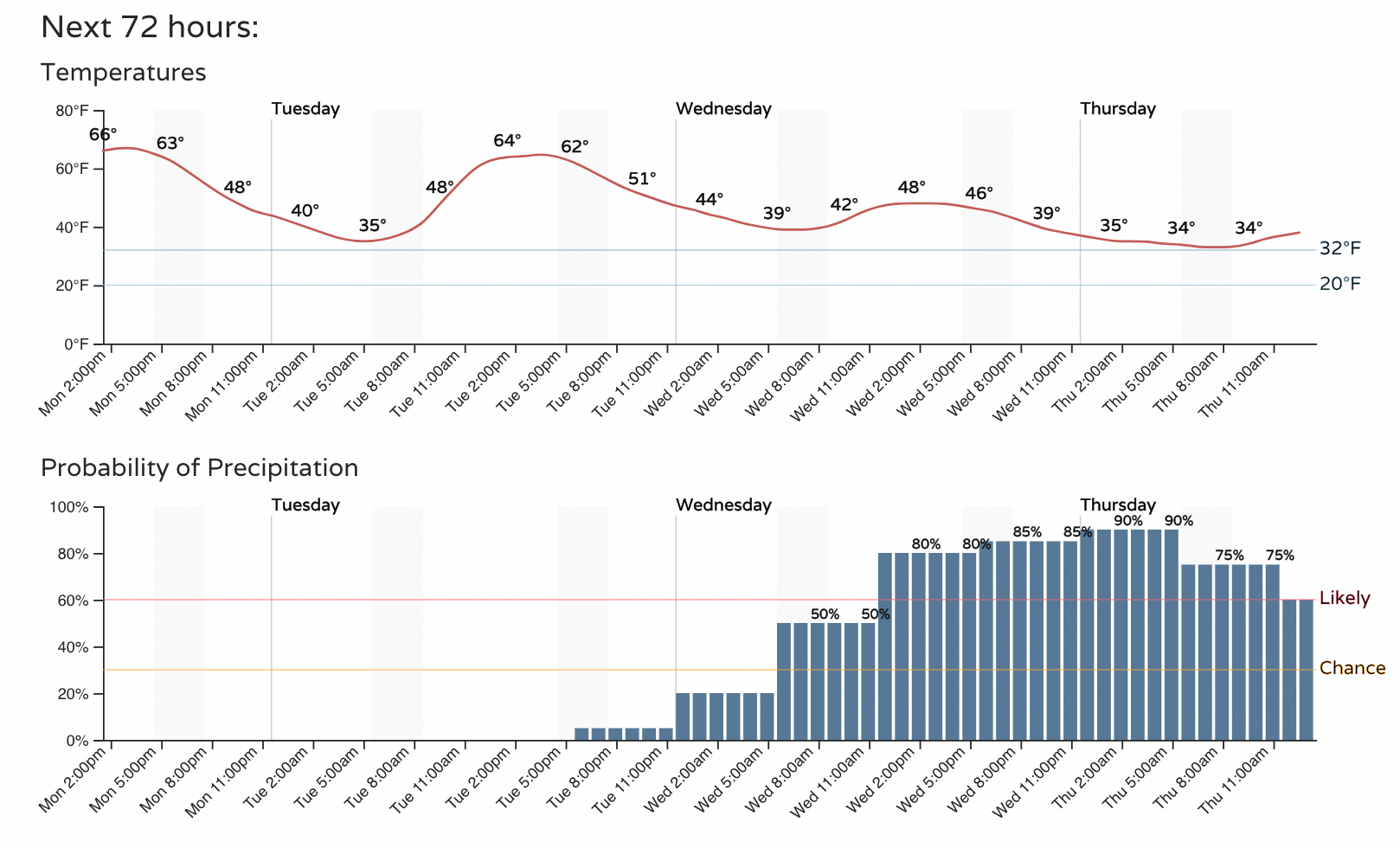
Today and tomorrow will remain quite mild across the region with big changes arriving on Wednesday and carrying through the day Thursday. The chance of rain and snow will increase through the morning and afternoon Wednesday, with the best chance for accumulating snow looking to come from Wednesday PM through Thursday PM.
Here's the latest hourly planner fort the Denver area:
Final thoughts
How does this all shake out? We'll see. Again, hard not to be a bit troubled by the setup overall, even as model guidance seems to be in pretty good agreement. In fact, this summary from the NWS in this afternoon's discussion I think is spot-on:
Despite an impressive signal from guidance over the past few days, our forecast confidence remains low-medium at this time. Why? There`s a few factors that play in here. The first, and most noteworthy, is that there are few examples of this synoptic pattern producing a significant snowfall across the Rockies. A 500mb low tracking towards the CA/AZ traditionally is not a favorable location for upslope. However, with this system the 500/300mb lows do not fully detach from the parent longwave trough, and the lead shortwave within the broad trough axis further complicates things. CIPS analogs show a broadly favorable pattern for snow here, but those events lacked the added complexity to the upper level pattern shown in the current forecast.
The lead shortwave will also likely continue to play an important role in the amount/strength of upslope and moisture advectioninto the region. This would be especially notable if the cutofftrends west/weaker and the lead shortwave ends up weaker/more progressive. Finally, we`ve seen several storms this season abruptly trend to less favorable solutions within 24-48 hours, and even though model consistency has been substantially better with this event (so far), it`s difficult not to have that thought in the back of my head until we finally break that streak.
We were just talking about what's likely to happen to that precipitation forecast over the next 48 hours, and couldn't agree more – the recency bias of what we've seen time and again this winter can't help but weigh our our minds.
Let's see how things look tomorrow!
With an impactful storm on the way, please stay weather-aware and as always subscribe to stay ahead of the incoming storm!