Denver area weather: Key to understanding the snow chances the rest of the week

Tuesday AM Update: How many different forecasts can a person see for a week? Seemingly, tons of them – especially the "social-weatherologists" posting every model update of the highest snowfall totals. The weather pattern for today through the weekend hinges on multiple things: a complex environment in which a stout storm lingers over the Southwestern U.S., a strong ridge develops to the northeast, and a tropical cyclone impacts the Gulf Coast; and these three features (plus several more) will dictate how the week actually progresses.
As the atmosphere tries to remain in balance, if you place a strong system over the Four Corner and a tropical cyclone over the Gulf, a strong ridge needs to develop somewhere to offset those features. The stronger one gets, impacts the others. We have yet to see how each of these features will impact the other, but there is increased clarity in data that arrived through this morning.
During the next few hours, a cold front will barrel through the area which will switch wind direction, increase potential for snowfall, and keep temperatures cold enough to discuss snow rather than rain or even a rain/snow mix for the Front Range. Most of the state has snow chances, except parts of the plains which will have some rain in addition to snow.
Here's an animation from Tuesday through later Wednesday:
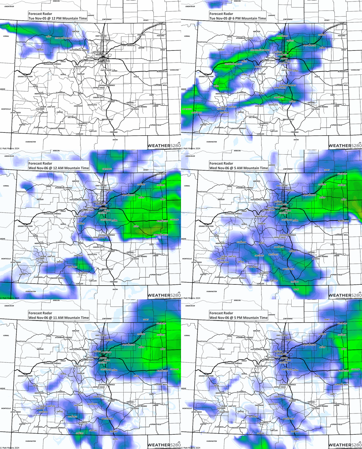
From that animation, we see chances of snow increase and stick around from later Tuesday through much of Wednesday. In hourly form, the chance in Denver looks like this:

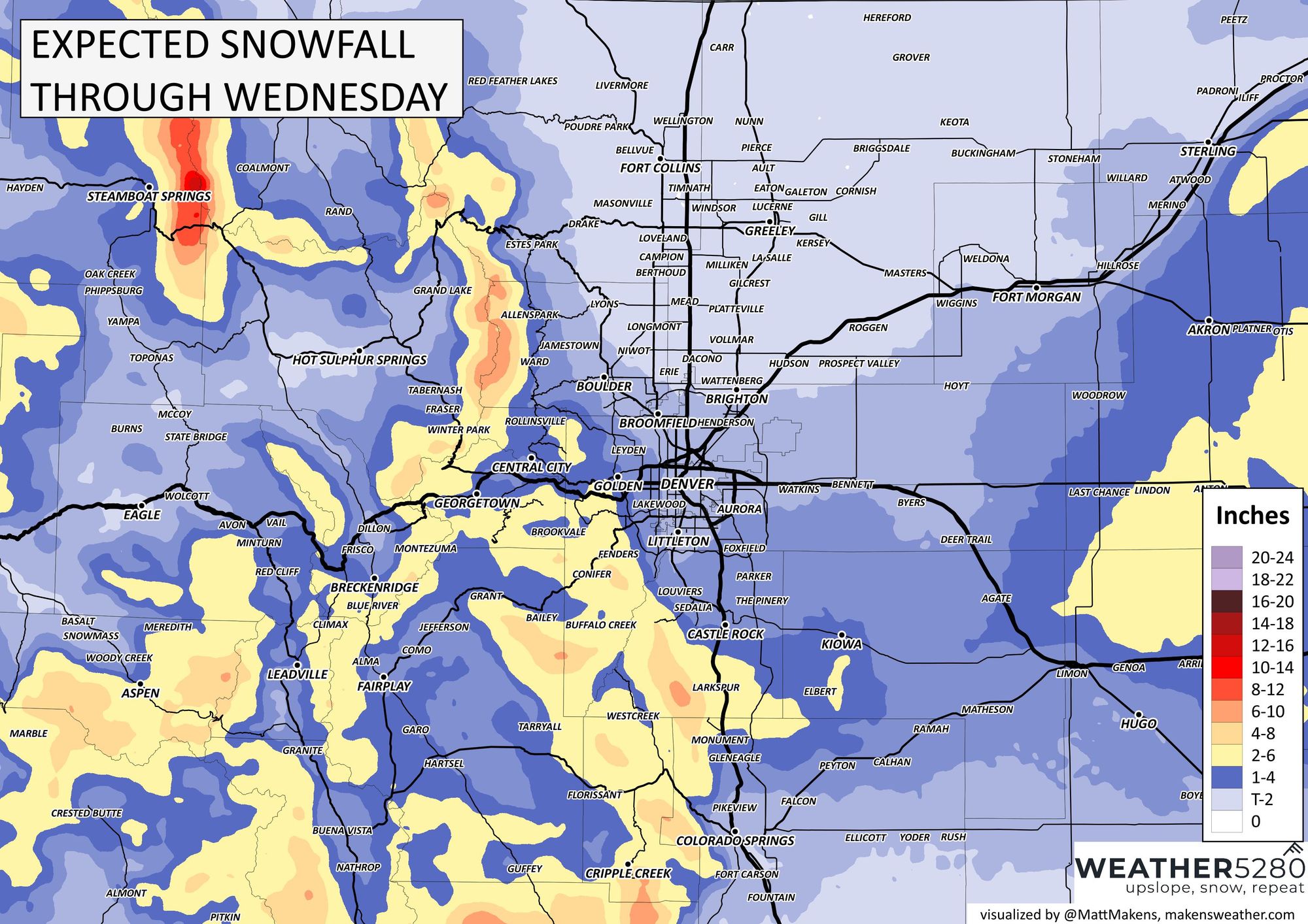
Snowfall forecast through Wednesday
From first snow chance, we can see the following totals as most probable, although there are totals much higher and some much lower across the northern metro locations.
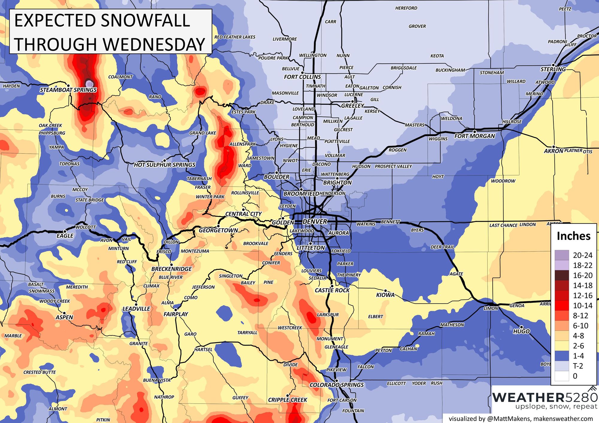
The biggest question mark at this point is how much snow to drop onto the Palmer Divide and how far into the metro area to pull that snowfall. Guidance is about split on just a dusting to 1" for Denver and higher end amounts of 3 - 5". Generally speaking, the further south and southwest you go from downtown Denver, the greater your odds are for accumulating snow between tonight and Wednesday.
Here is the statewide view. Should be some spots of pretty good snowfall for the foothills west of Denver, the Palmer Divide, and east-central Plains:
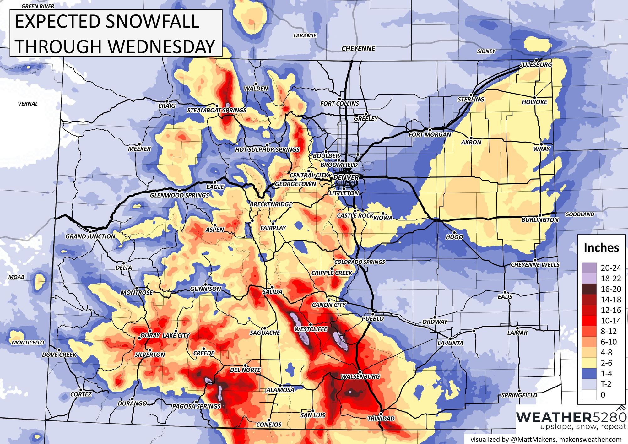
For now, we remain watching this first wave of snowfall to see how it plays with terrain and where the forecast is potentially too low, or high if the case may be.
I was asked this morning at school drop-off to give the forecast... 0-18" I said... tongue-in-cheek obviously, but we are playing with the difference of less than 100 miles to see this thing crank up a lot of snow or waking up to very little Wednesday morning.
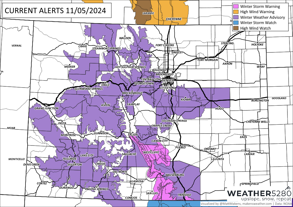
The NWS remains watchful also, and has parts of the Palmer Divide in a Winter Storm Advisory, meaning:
...WINTER WEATHER ADVISORY IN EFFECT FROM 8 PM THIS EVENING TO 8 PM MST WEDNESDAY...
* WHAT...Snow expected. Total snow accumulations between 2 and 7 inches. Winds gusting as high as 35 mph.
* WHERE...The Southern Front Range Foothills, and Castle Rock.
* WHEN...From 8 PM this evening to 8 PM MST Wednesday.
* IMPACTS...Plan on slippery road conditions. The hazardous conditions could impact the Tuesday evening and Wednesday morning commutes.
What happens beyond Wednesday?
What happens beyond Wednesday hinges on a lot of factors, as mentioned way up at the top of this post. The parent storm system will drift over and stall out on the Four Corners region. Leaving this energy in place will continue snow chances for several days until this system exits. When, how quickly, and the path it chooses to exit will either keep us with trivial snowfall totals or grabbing the snowshovels.
Under any scenario, it looks like the biggest impact will be across the Plains where a lot of water will fall. The question remaining to be answered, how close to Denver will that system exit later this week, and if we're watching it pass us by or talking another round of snow.
That's for our next discussion. Stay tuned.
