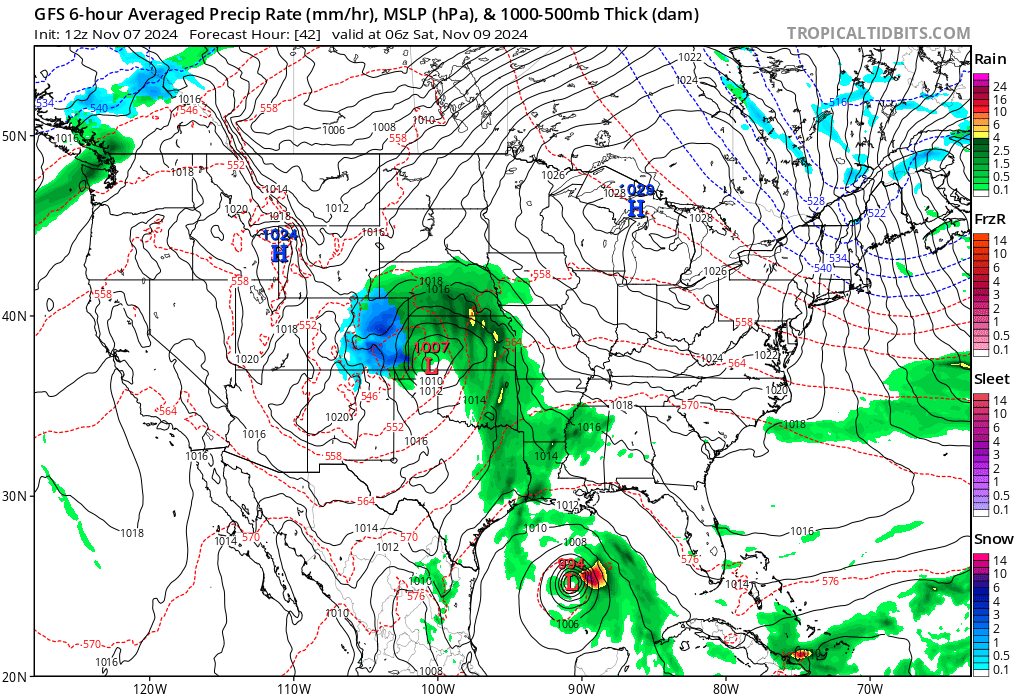
Winter Storm Warning for Denver Friday; Heavy snow set to bury the Plains

I can't really recall the last time a multi-day, multi-wave, highly complex system not only over-performed on its initial offering, but then would up delivering on the back half of the event. It's looking like this system will try to manage just that, at least for Denver and points south and southeast.
Further north – we hear you – frustrating to be left out of the action, but it actually looks like you've got some hope getting in the action with this final push, we'll see.
How much snow so far?
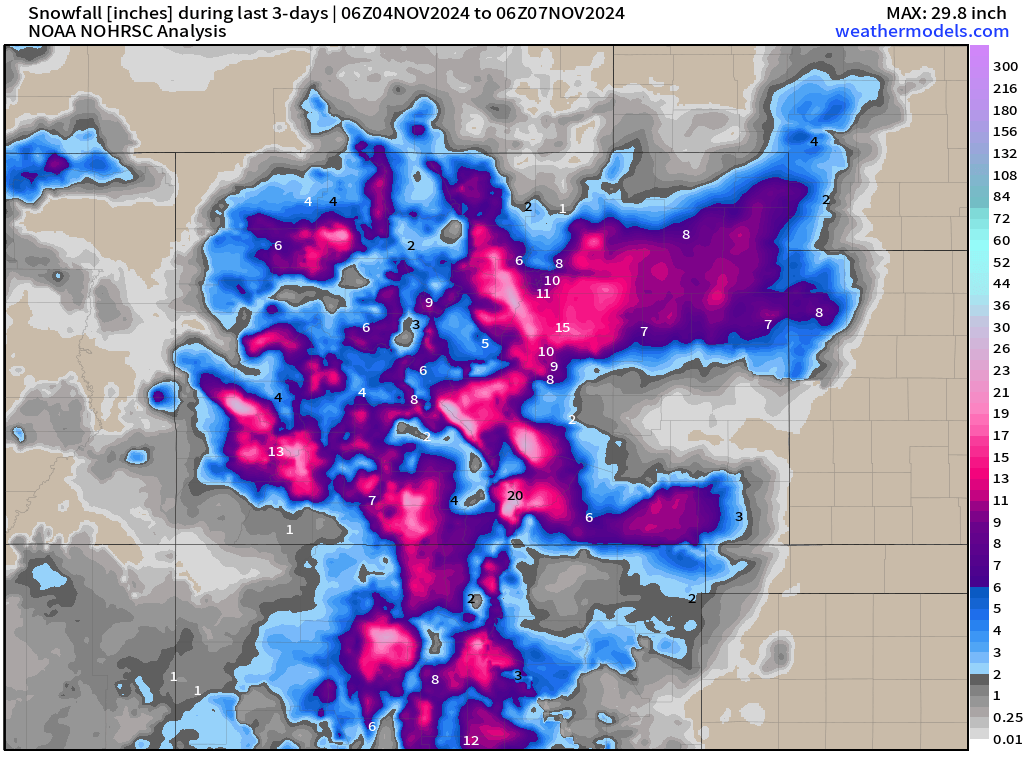
Through early this morning Denver has record 6.2" of snow officially (at DIA), with more for many of us, especially on the western and southern portions of the city. What a flip from October!
Three day snowfall totals shows who's seen how much, with much of the state picking up measurable snowfall over the last couple of days, and plenty more is on the way!
The setup
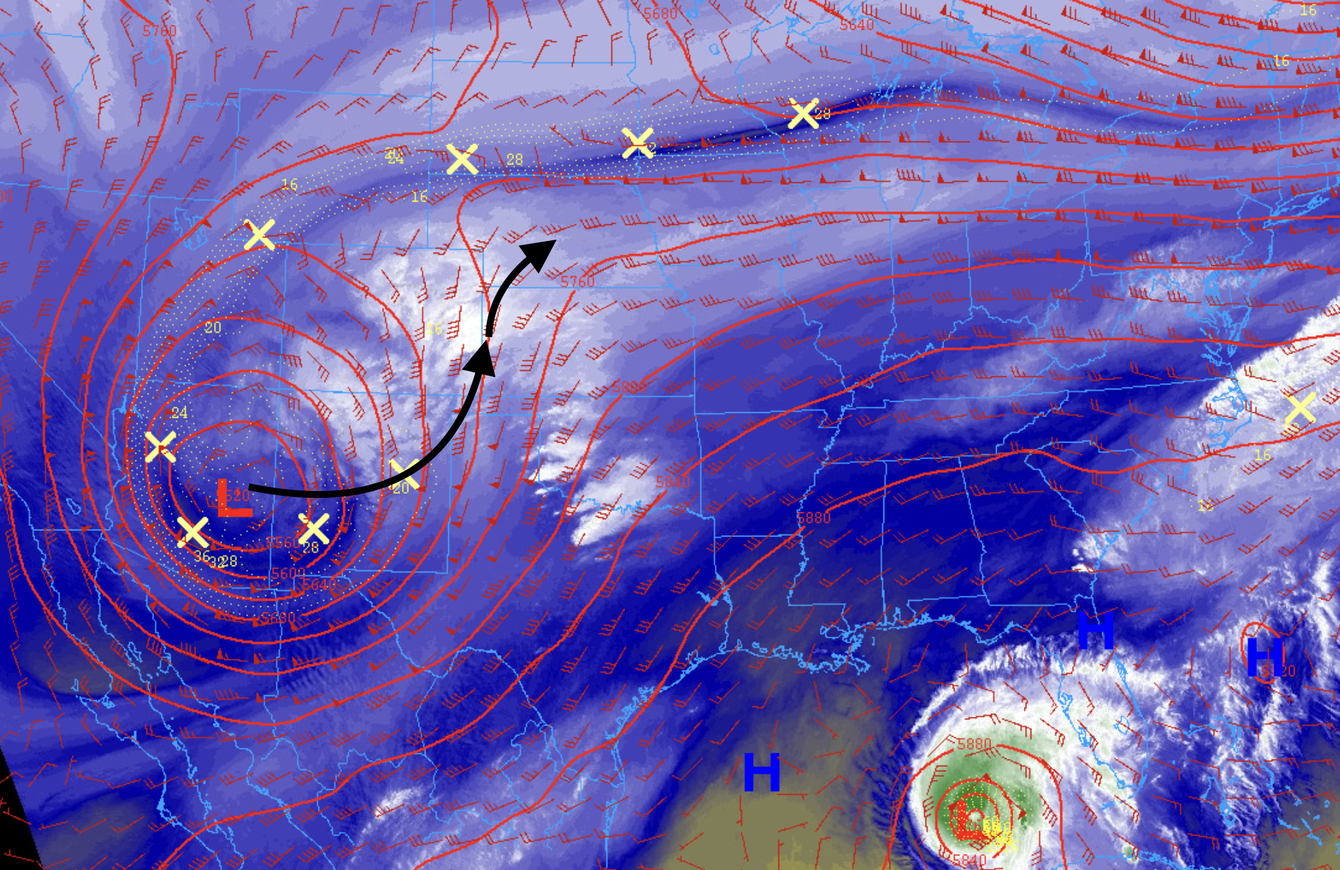
Despite the snow we are seeing today, the main feature (low) is still well to our southwest. After the initial energy dropped through Tuesday night, things haven't progressed much – and won't until we move into the day Friday and Friday night into Saturday.
You can see in current water vapor the low (red L) sitting over Arizona this morning. It'll gradually creep east then turn northeast through tonight, eventually tracking along the Colorado/Kansas border Friday night into Saturday.
You can see that in the animation below, which the the positioning of the circles/blue as they track from our south, to east, and eventually eject northeast.
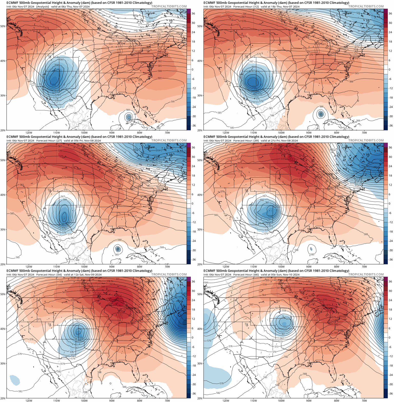
This is beautiful setup for a lot of snow across eastern Colorado.
While the energy might favor areas further south and east (vs Loveland, Fort Collins), I'd argue the trend today would include more of those southern cities in getting some measurable snow before things are said and done on Saturday.
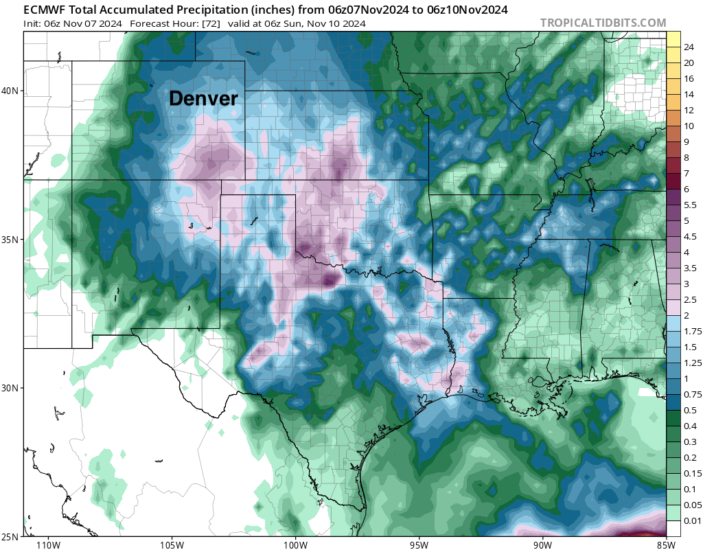
If we look at forecast QPF (precipitation) between now and Saturday night, we see just a tremendous amount of water forecast for Southeast Colorado. Upwards of 2" for a good chunk of this area on this particular model. You'll note, lesser totals up toward Denver and points north... but not dry!
Snowfall forecast
As mentioned above, a Winter Storm Warning goes into effect for the Denver metro area tomorrow morning and extends through Saturday morning:
WINTER STORM WARNING IN EFFECT FROM 5 AM FRIDAY TO NOON MST SATURDAY...
* WHAT...Heavy snow expected. Total snow accumulations between 7 and 14 inches, with the heaviest amounts south of I-70. Lighter totals of just 1 to 4 inches north of Boulder.
* WHERE...The Southern Front Range Foothills, Boulder and the western suburbs of Denver, and Denver.
* WHEN...From 5 AM Friday to noon MST Saturday.
* IMPACTS...Travel could be very difficult. The hazardous conditions could impact the Friday late morning and evening commutes.
For totals we're thinking the following, with room to adjust as we head into Friday.
- Fort Collins: 3-8"
- Boulder: 6-12"
- Denver (downtown): 6-12"
- Southeast Denver: 7 - 14"+
- Conifer: 6-12"
- Castle Rock: 6 - 12"+
- Elizabeth: 10-16"
- Colorado Springs: 6 - 12"
- Limon: 10-16"
Modeled forecasts:
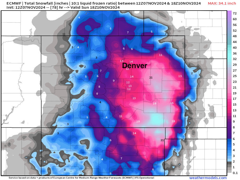
The European ensemble mean is probably a good place to start, though is at the high end of what we think is potential in Denver. Still, overall hard to argue much here, and shows that some of our northern communities could see several inches before things are through:
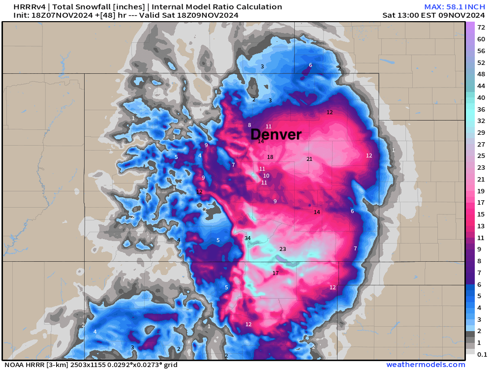
The HRRR (below) is closest to our forecast right now. Note the heaviest totals across southern and eastern Denver metro, with less upslope north and west:
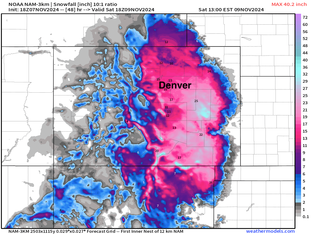
And the 3km NAM showing high-end potential across the entire area – would no doubt be a boom scenario!
Greatest boom and bust potential
Eventual track and to a lesser degree temperatures will impact eventual snowfall totals. A slightly further east track would limit snow up into Denver and points northwest, while a more westerly track would bring "boom" snowfall totals to these areas. Also worth noting, some guidance shows snow mixing with rain at times at lower elevations, which obviously would hurt snowfall forecasts!
For greatest boom we think Denver's southern and eastern suburbs could end up under an impressive band as things get going in earnest later Friday which could over deliver in these areas again. Think Southeast Aurora on this.
For greatest bust potential, likely Denver and points north, where temperatures and or track could rob us of upslope and high end snow totals.
All this to say, greatest confidence across the plains where BIG totals are expected, with Denver on the edge – a foot of snow almost as likely as 4". Yikes!
Planning and impacts
This has been an impactful event, and will continue to be one through the end of the week and into the early part of the weekend. There will also be a substantial increase in the wind through the day on Friday through early Saturday for some areas. Those areas at greatest risk for blizzard conditions will be in the following areas: Elbert County, east/northeast El Paso County, Lincoln County, Kit Carson County, Cheyenne County and the majority of the southeast corner of Colorado where snow has occurred or will occur. Gusts of 30-45 mph will likely occur in these areas. Considerable blowing and drifting snow will occur making for a dangerous scenario, especially Friday night. Below is a look at where the greatest impacts are expected through the remainder of the storm, which could be adjusted as we head into Friday, stay tuned.
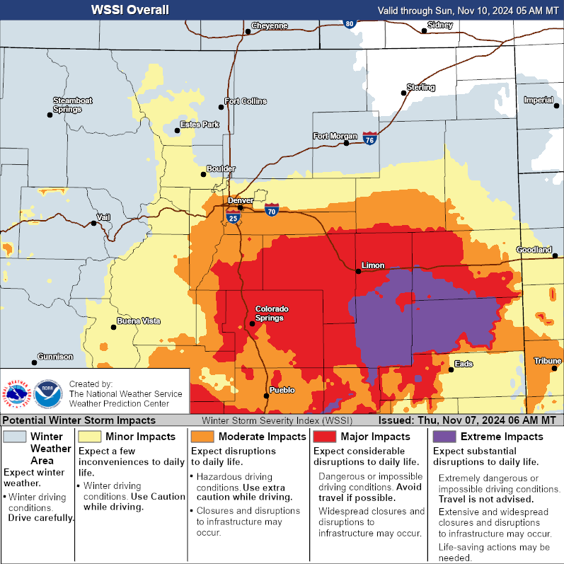
As for timing, look for snow showers to taper off today, with low snow chances through most of tonight.
Snow chances increase from south to north on Friday, with Denver's best window for accumulating snow coming between 6am Friday and 9am Saturday.

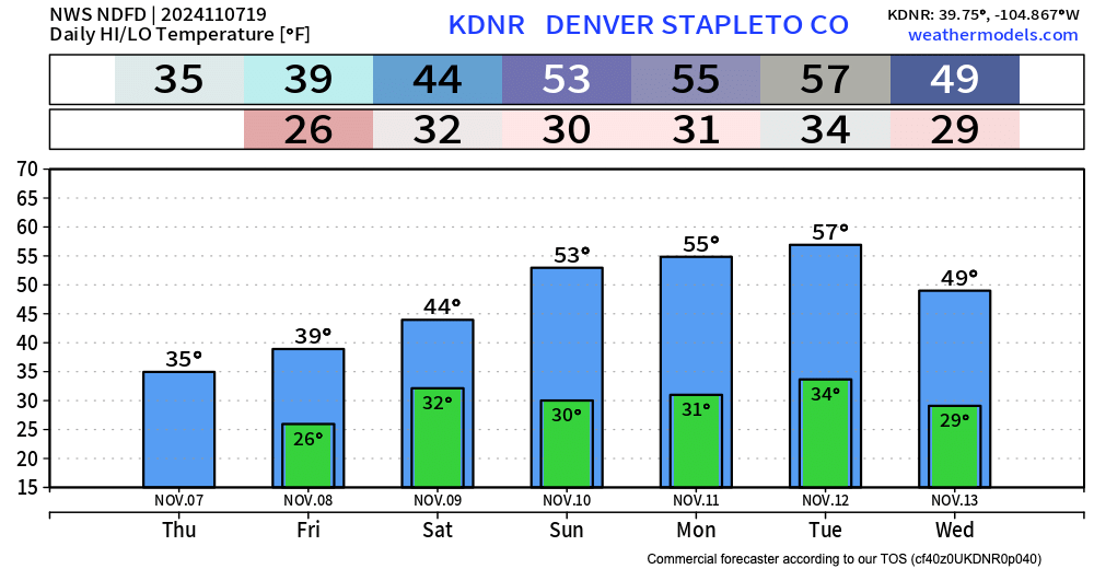
Temperatures gradually moderate as the storm exits on Saturday, but will remain chilly.
☃☃☃☃☃☃
Stay tuned, and as always – Please subscribe, it's free!
☃☃☃☃☃☃️
