From Spring to Snow: A Dramatic Weather Shift Ahead for Denver and the Front Range

If you’ve been enjoying the warm sunshine lately, take it all in today and tomorrow—because a dramatic shift in the weather is on the way for Denver and the Front Range. We’ll go from springlike warmth and breezy afternoons to 'wintry snow' and wind chills, all in a matter of hours.
Let’s walk through what’s ahead—and what it means for your weekend plans.
☀️ Wednesday: Warm and Pleasant
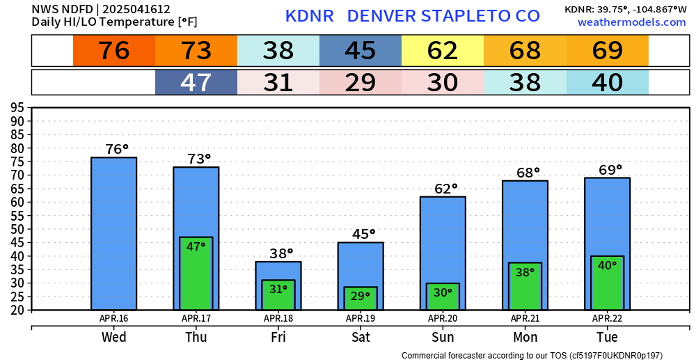
Today will be the warmest day of the week, with mostly sunny skies and highs in the mid-70s. Winds will stay generally light. It’s a great day to be outside, but if you’re heading into foothill areas or down toward the Palmer Divide, be aware that vegetation is drying out quickly and these areas have the higher fire danger conditions.
🌬️ Thursday: Breezy and Warm, Then a Quick Turn
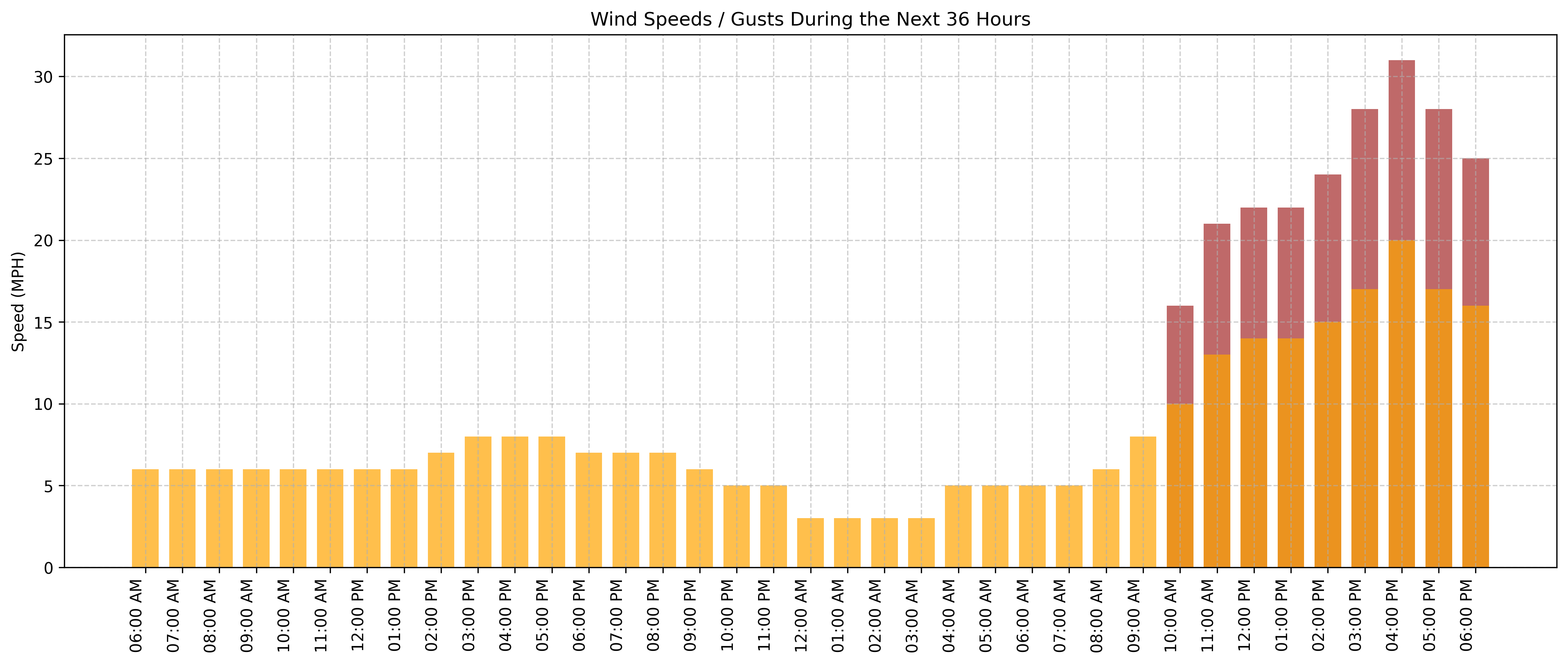
Thursday starts off nice again, with highs near 73°F under mostly sunny skies. Winds will increase through the day, shifting from southwest to northwest at 15–20 mph, with gusts topping 30 mph.
With low humidity and strong winds, critical fire weather conditions will be possible Thursday afternoon, especially over the southern third of the region.
But the real change hits Thursday evening.
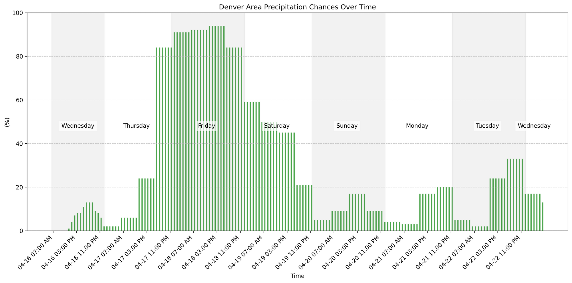
🌧️🌨️ Thursday Night: Rain Quickly Turns to Snow
A potent storm system sweeps through Thursday night, bringing widespread precipitation across the region. What starts as rain before midnight will rapidly transition to snow, especially for the higher elevations of the metro area (say 5,000 feet and higher) and into the foothills.
Temperatures will drop to below freezing overnight, with gusty north winds making it feel even colder. While snowfall totals look light—generally under an inch or two for Denver—slushy roads and reduced visibility could develop late Thursday into early Friday. Plus, some areas of heavier snowfall for the foothills and in NoCo.
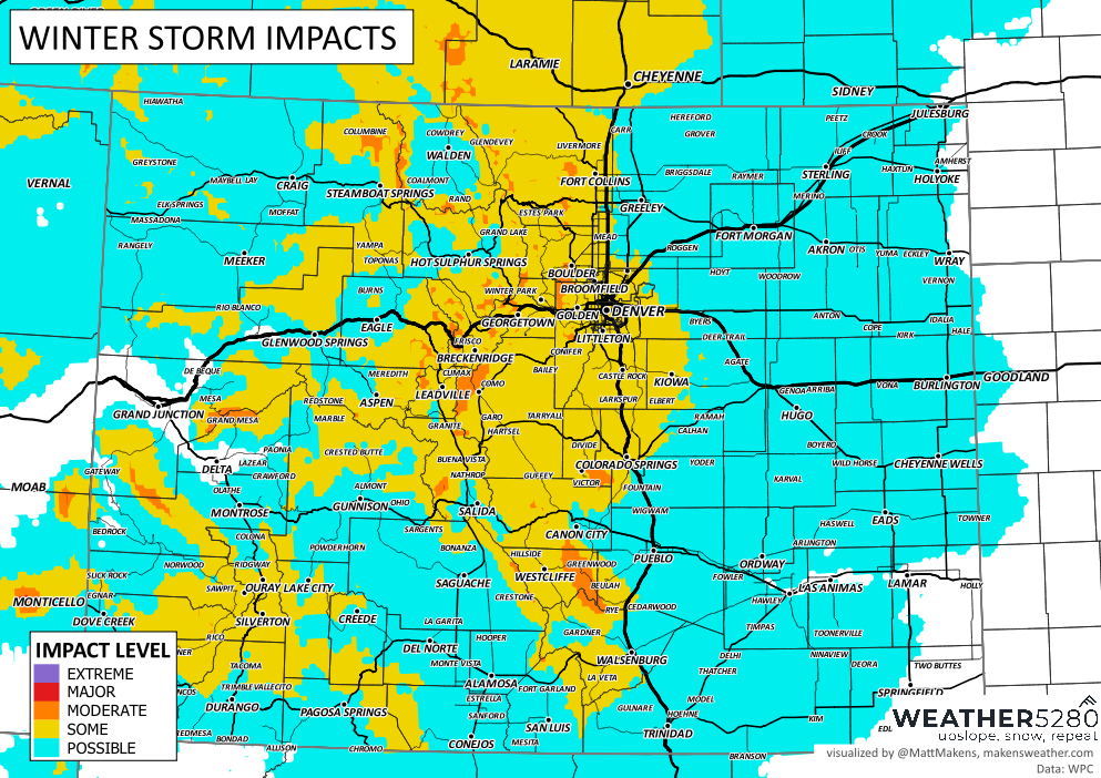
Starting Thursday night, going through Friday, travel impacts across the region are shown here:
❄️ Friday: Cold and Snowy
Friday is a classic spring-snowy day: temperatures will stay in the 30s, and snow showers are likely throughout the day. Winds remain from the northeast, adding to the chill.
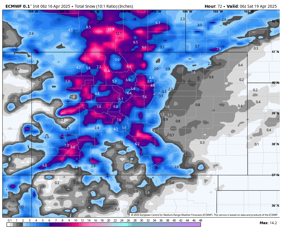
By Friday night, another round of snow is expected, with lows falling below 30 this time. This system could bring accumulating snow, especially to the Palmer Divide, foothills, and higher elevations. We have been liking how the ECMWF modeling has been looking, although with a spring snow like this we will see lots of variety in model outputs and you will undoubtedly hear many versions of what could potentially fall. We will send out a snowfall forecast for the event Thursday.
For general planning, something like this feels most reasonable out of the modeling as of this morning. This shows a couple of inches for the metro locations along I-25, upwards of six inches, at least, for those in the metro area west of I-25 into the foothills. There will be pockets of a foot plus from Floyd Hill westward.

🌦️ Weekend Outlook: Gradual Clearing
Saturday will still feel wintry, with a chance of morning snow showers, transitioning to a mix of rain and snow by afternoon. Highs will hover in the mid-40s, and skies remain mostly cloudy. Sports are subject to some cancellations if fields are wet enough.
Saturday night into Sunday, the storm system begins to pull away. Sunday looks like a transition day—partly sunny with a high near 62°F, and only a slight chance of an afternoon shower.
🔍 Bottom line:
Fire Weather Thursday PM: Warm, dry, and windy conditions could elevate fire danger in southern areas before the storm arrives.
Fast Weather Flip Thursday Night: Rain changes to snow quickly—expect slushy/icy spots Friday morning and slushy areas throughout the day Friday.
Chilly Weekend: Friday and Saturday will feel more like February than mid-April.
Milder Pattern Returns: Temperatures rebound starting Sunday, with gradual warming expected into early next week.