How February snows have helped shape Colorado's 2019 - 2020 snow season

It's been a roller coaster winter for Colorado, and February was certainly no exception. January was warm and dry, and many people feared it signaled the end of winter and beginning of drought. But after a gloriously beautiful spring-like beginning to February, the "mild switch" was turned off.
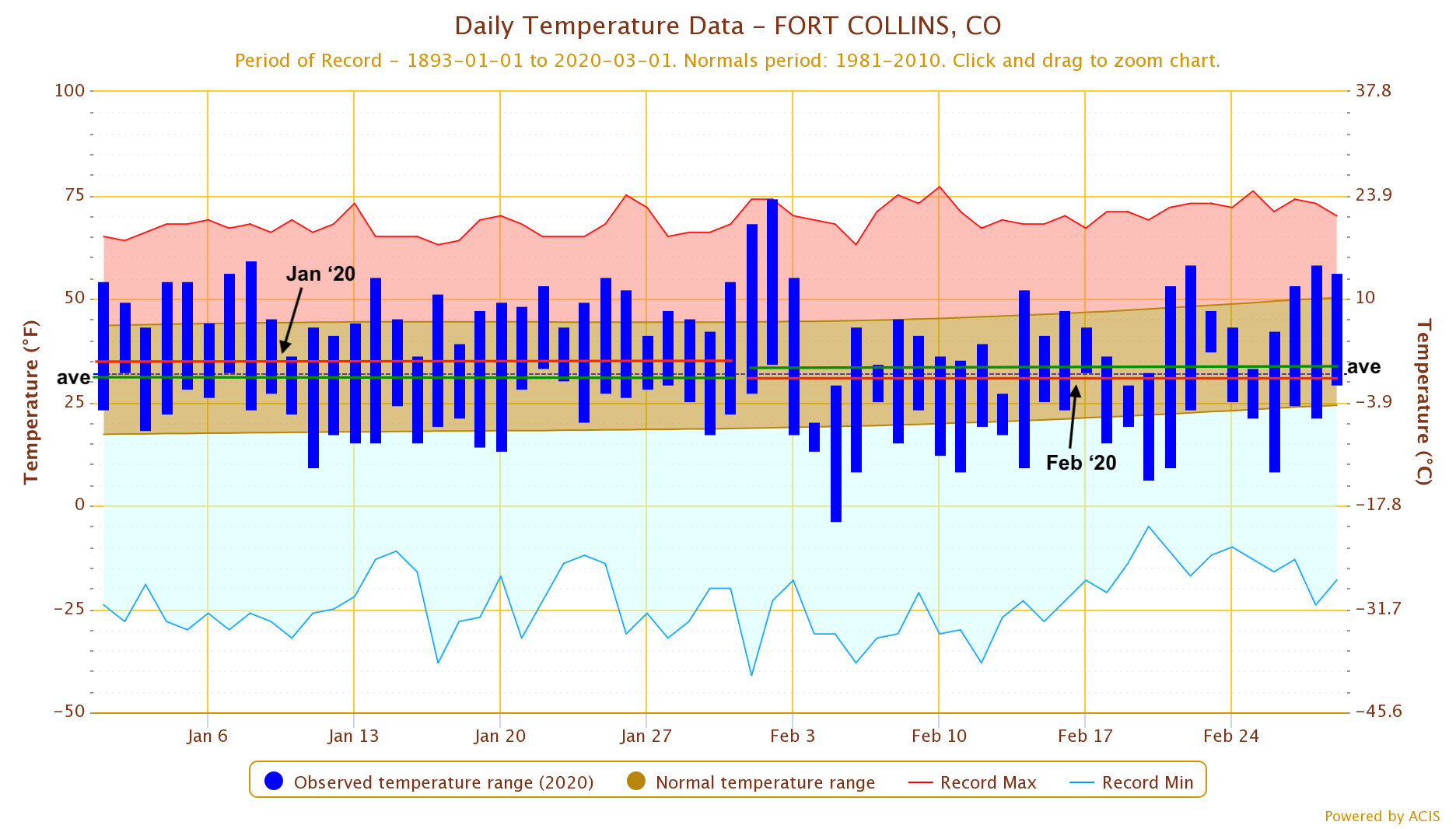
Take a look at this graph of daily temperatures compared to average for Fort Collins. While both January and February are part of winter, the long-term trend indicates that February is usually warmer than January as we get closer to spring. This year, that pattern flipped for many locations, and January was actually warmer!
Not only temperatures, but precipitation (i.e. snowfall) really kicked into high gear in February after a lackluster January. Below are the snow totals for February across the state on the left side and departure from average on the right side.
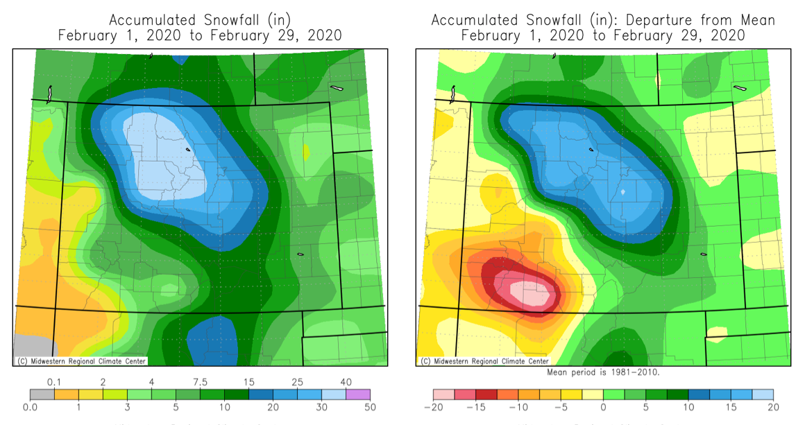
While a significant portion of the state received above average snowfall for the month, the San Juans in southwest CO have unfortunately struggled. Even though the southwest saw consistent storm activity through the entire month, the total accumulations just couldn't keep up with average. For Wolf Creek Pass, they average about 1 inch of moisture every week this time of year. It's easy to get a lot, and it's also easy to fall behind very quickly.
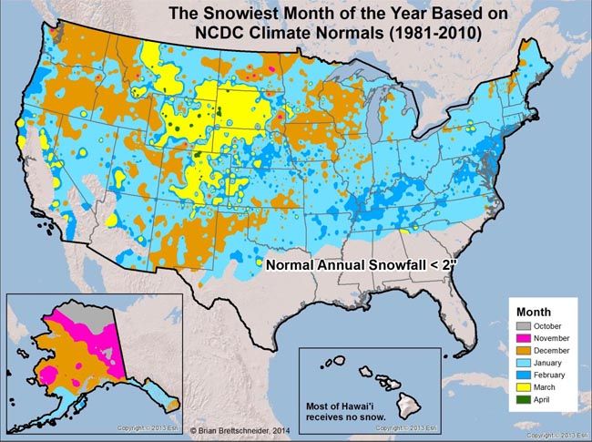
On the flip side, the northern Rockies, the Front Range, and the urban corridor saw quite the boost in seasonal snowfall totals. While February snow can always be expected, February is not really the month we think about when it comes to snow climatology. Climatologist Brian Brettschneider showed us (below) that while much of the west slope sees the most snow in December, for almost half of our state, the snowiest month is March.
Odds are, at the end of this snow season, we'll be talking more about what happened in February. Let's look at some of the snow statistics from February. Of the long-term (> 50 years) National Weather Service COOP stations in Colorado, 14 stations experienced one of their top five snowiest Februaries on record. Here's the list of stations with their February snow total, what it ranked, and what the average February snowfall is:
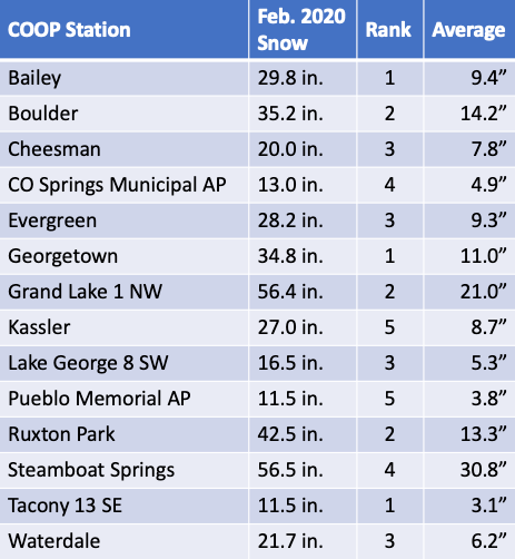
Also worth noting, although not ranked in the top 5, the station at Climax, Colorado (in Lake County) observed a whopping 61 inches of snow for the month. That's more than Denver's entire seasonal average!
Now that winter has officially ended (meteorological winter is Dec-Feb), let's see where we're at in terms of seasonal snowfall.

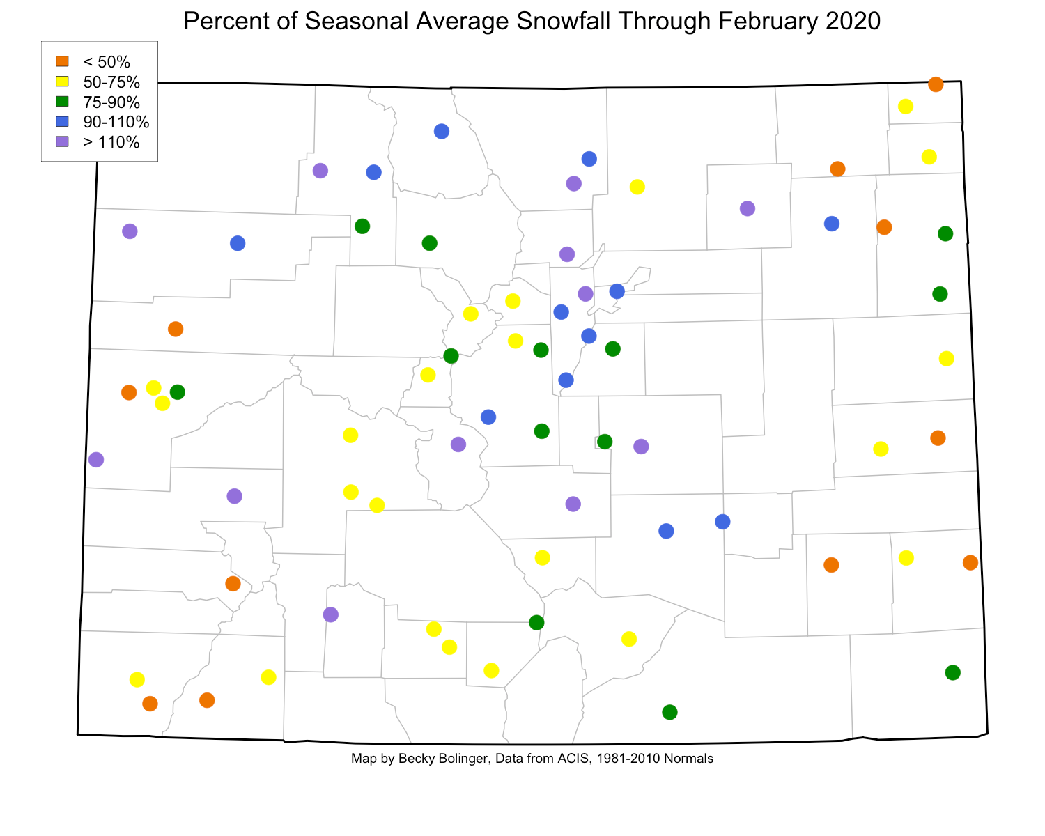
This map shows the current seasonal snowfall-to-date as a percent of the entire seasonal total average (what we typically expect from October-May). Even though there are still 3 months with snowfall potential left, many locations in the state are near or above their total seasonal average. Steamboat, for example, normally observes about 179" of snow in an entire snow season, and this year, they've already measured 192" (106% of average). With the help of February precipitation, Boulder is already at 112% of their seasonal average, and out on the eastern plains Fort Morgan is at 125% of their seasonal average.
Some areas have struggled a bit more, and of particular concern is the southwest corner of the state. Mesa Verde National Park in Montezuma County, having received almost no snow in February, is currently sitting at 55% of average. According to data from the NRCS Colorado Snow Survey, snowpack in the San Juan mountains is at 87% of average, and is likely to peak below average as well.
Whether you're in an area that's struggling, or you've seen enough snow to last all season, don't let the warm temperatures this weekend fool you. According to this tweet from Brian Brettschneider, most of Colorado's lower elevations typically see more than 6 inches of snow from March 1 to the end of the season and the higher elevations still get an average of over 24 inches before the snow season is over!
